Monday 31 December 2012

Don't park a ship in our city

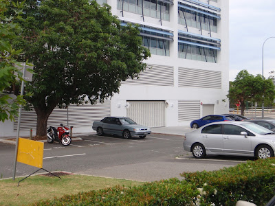
Is this the ugliest building in Perth?  Probably not.  It could be the most anti-social.  This is not a warehouse in an industrial zone, this is an office building in urban Perth. 


Just two kilometres from the heart of the city and 400 metres from the Leederville train station.  It holds a prime position on the corner of Cambridge Street and Harrogate Street, Leederville.  A landmark building in what is becoming a high-volume pedestrian area.


The design is similar to an ocean-going car carrier. 


This is the view at ground level.


Why would someone design a building like a ship? 

To hold cars.  Those first two levels are for car parking and the upper three levels are offices. 

I am sure that the occupiers of this building have a fine view from the "bridge".  They would be able to look out across the city from their elevated position.  Unfortunately the rest of us, at street level, have been given a towering wall of concrete.

How does this happen?  The current local building requirements from the Town of Cambridge specify that for every 100 square metres of office floor area, 3.3 car bays must be built on site.  This is a lot of space for cars.  Once you combine the parking bays, turning areas, driveways and ramps, this rule means the floor space dedicated to storing cars is nearly 40% of the total building. 

Most importantly, this "need" for car parking can affect what happens at street level quite dramatically.  A liveable street can be turned into a concrete canyon.  The amenity of walking and bicycling can be removed.

I have no objection to a five-storey building.  Actually, I think increasing the density of Perth's urban areas should be encouraged.  However, we deserve better than this.  If we keep allowing this type of construction, our quality of life will be degraded.

Why does this building have all the car storage above ground?  With Perth's sandy soils it is relatively simple to go down a level or two.  It will probably cost more.  Property developers, looking for short-term profits, are not likely to spend this extra money unless they are given no option.  That is exactly what we need to do.  We need to protect the liveability of our streets and ensure that the public zone is active.

To be fair, I will show the other sides of the building.  It is not blank concrete all the way around.  There is a small cafe space on the south-west corner.  It is currently vacant, but this small area has potential to become active.


Apart from the cafe, the majority of the building is dead for the first two levels.  The southern facade has the addition of vented grills, they break up the walls, but there are still two floors of car park.


There are two issues to address: firstly, if we accept that buildings need to provide some car parking for the occupants and visitors, what design requirements should be applied?  And secondly, does the 3.3 car bays per 100 square metres rule make sense?

The Town of Cambridge has recently reviewed its parking strategy.  It was done by Luxmoore Parking Consulting and is very extensive.  Over 200 pages about parking, probably more than you would ever what to know.  Here are a few quotes from the report:
  • The commercial centres have been designed more to accommodate vehicles rather than people because for too long, parking policies have assumed that all trips will be by car and all parking should be free.
  • Free parking contributes towards a host of expensive and undesirable consequences which are not fully appreciated by many drivers.
  • Based on the current 'predict and provide' approach, the estimated future requirement for parking supply for development proposed over the next 30-40 years is unreaslistic. In addition, the current road network will not support the volume of traffic that will be created by this level of parking.
  • Parking for cyclists should be given a high priority and planning requirements should ensure that adequate parking provision and end-of-trip facilities for cyclists be incorporated into all new developments.

Having said all the above, when it came to the recommendations about parking ratios for office developments, Luxmoore have recommended a reduction to 2 car bays per 100 square metres but not until 2017.  A further reduction to 1.25 car bays per 100 square metres should happen before 2022.

In my opinion, this is not soon enough.  I want a better city now. 

Luxmoore also stated that:
  • It is recognised that changes to the management of parking and to existing attitudes towards parking supply will not be achieved quickly. Gradual changes and education are necessary to alter the mindset of stakeholders and to create a more sustainable transport and access environment in the Town.

Policies to reduce the number of cars should come from our governments: local, state and federal.  We need people in government with guts and vision to cut through this "waiting time". 

The Town of Cambridge are calling for public comment on their new parking policy revision until 25 January 2013.  If you want to give them encouragement and let them know it is OK to reduce those ratios now, you can use the link here.  And perhaps ask them why some buildings look like ships.


Thursday 27 December 2012

A year of videos

Here are some of my favourite videos from the past year or so. I thought it would be good to have them all in one place.


SENATOR LUDLAM ON CYCLING
His presentation of the Greens political party Bike Vision 2029 Perth Bike Plan. Common sense thinking about the bicycle. "We've got to kick this idea that only serious infrastructure is freeways, railways and ports". 


CYCLING WITH MEREDITH
This one is from the video bloggers Cycling with...
We ride through the streets of Amsterdam with a charming girl for ten minutes. What's not to like. "Meredith is originally from the Bay Area in California. Her father being dutch, she has always wanted to live in the Netherlands." She tells us about why she enjoys her new home and we get to see the streets of Amsterdam that we hear so much about. A simple idea, done very well.


HOW THE DUTCH GOT THEIR CYCLE PATHS
The Dutch are have not always had great cycling infrastructure. This film explains some of the history and the important decisions made in the 1970s that put them forty years ahead. One of several great films by Mark Wagenbuur at Bicycle Dutch.


CYCLING FOR EVERYONE
This film introduces the recently established organisation the Dutch Cycling Embassy. There is no point trying to reinvent the wheel. The Dutch have the knowledge and they want to share.


CICLOVIA: BOGATA, COLOMBIA
This film has been around since 2007. Produced by Street Films it shows us the weekly event in which 70 miles of city streets are closed to traffic. Perth's Freeway Bike Hike could learn a few things from this.


MELBOURNE: A PEDESTRIAN PARADISE
Another one by Street Films. A great explanation of some of the things that Melbourne has done to revitalise the city area. It was produced in 2008 but is still relevant for Perth.


SAN FRANCISCO: REMOVAL OF THE EMBARCADERO FREEWAY
Also by Street Films. This story about freeway removal has relevance to Perth's new Elizabeth Quay development and the rerouting of Riverside Drive. They removed the freeway and the sky didn't fall in. The traffic "disappeared" and life was improved. I will probably expand on this later.


MESSAGE... FROM DUBLIN BIKES
A film by Mike Rubbo. A bike share scheme will not work in Perth until after the helmet law is repealed. Mike interviews Dublin councilor, Andrew Montegue and we learn about the success of the bike share scheme in Dublin.


HAL GRADES YOUR BIKE LOCKING
New Yorker, Hal Ruzal tells us how to lock a bike. This is the third in a series. You can find the others here, along with more than a hundred other short films from Street Films.


BIKE LANES BY CASEY NEISTAT
New York again. Casey Neistat reacts to getting at ticket. This one has had over six million hits on YouTube.


MY CAT CAN RIDE...
I can't have an internet video collection without a cat.


LADY ON A CROSSWALK
This one has been around for a long time. It is still one of my favourites.


DANNY MACASKILL - WAY BACK HOME
MacAskill is the bicycle rider's Ken Block.


Sunday 23 December 2012

Shopping with a bicycle

On Friday I decided to visit Claremont to buy some new socks. It was a beautiful day and I wanted a reason for a ride. I could have gone into central Perth but I decided to find out how the "shared space" in Bay View Terrace was progressing. I did a blog post about it in October. At that time there were no bicycle racks installed. I was not too critical of that issue because there were still a few jobs being finished within the street and I hoped they would come later. Well, it has been two months and there are still no bicycle racks. In practical terms it is probably OK. As you can see from this photo, the tree protectors serve as convenient places to lock our bicycles. 

Bay View Terrace, December 2012

There are two racks around the corner in St Quentin Avenue but they were not being used, perhaps because they are a bit out of the way and in a section of dead space next to the side wall of a bank. 
St Quentin Avenue, December 2012

The tree protectors are not ideal because the metal is sharp and care needs to be taken if you want to avoid scratching your frame. This lack of official bicycle parking prompted me to research what the Town of Claremont had provided prior to the change. A quick look at Google street view, which still shows the old street, reveals there were previously eight u-rails spaced along the two blocks. 

Bay View Terrace, Google street view, January 2010

From eight to zero! That does not fit with the new movement hierarchy we were promised.


One change since October has been the reduction of the posted speed limit. It was previously 20 km/h and it has now been reduced to 10 km/h. From my observation, the new limit has made no difference to the actual speed of vehicles. Cars still dominate the space and motorists are ignoring the speed limit. In desperation, the Town of Claremont have installed this huge illuminated sign that flashes between  showing the speed limit and a plea to motorists to slow down.


Sad isn't it. The Town of Claremont do not understand what they have done. Despite spending a lot of money on attractive paving, they still have a street the welcomes motorised traffic. What could be an attractive pedestrian mall is still used as a short-term car park. They have even increased the number of car bays from 31 to 32 and removed eight bicycle u-rails. A sign is not going to fix anything. The answer is simple.  Just get rid of the cars.

It is time for some thinking from this century. I noticed that the Heart Foundation in South Australia has been doing some useful research and have commissioned this Good for Business - Discussion Paper


Written by Dr Rodney Tolley, the report gives information "for built environment professionals and business people to show the positive financial benefits of making streets more walking and cycling friendly". This should be essential reading for all Western Australian Local Government decision makers. Some of the key findings shown in the report are: 
  • Space allocated to bicycle parking can produce much higher levels of retail spend than the same space devoted to car parking.
  • Car parking is of less significance to local retail activity than is often thought. Space for people on foot is a more significant attribute.
  • Retail vitality would be best served by traffic restraint, public transport improvements, and a range of measures to improve the walking and cycling environments.
  • There is evidence that improving walking and cycling environments raises property values by statistically significants amounts.

My shopping trip was a great example. I found the socks and then bought new underwear as well. I remembered that I needed to replace my swimming goggles, so I walked around looking for a sports store. I was not in any hurry.  I had ridden by bicycle instead of driving my car, I did not have to worry about any parking time-limits. After buying goggles, I decided that because Christmas day is getting close, I should not procrastinate about buying gifts any longer. I eventually spent three hours shopping in Claremont. I started with socks, then ended up buying six additional items plus some fresh vegetables to have with dinner.

Importantly, most of my time, and money, was spent away from the Bay View Terrace car park and in the Claremont Quarter Shopping Centre.

Merry Christmas to all 

Saturday 15 December 2012

Perth Stadium transport plan


The transport plan for the new Perth Stadium was released yesterday (3.1MB PDF).  Bicycles do not get a mention. I am tempted to turn this into a rant but I will try to contain myself.


The alternative title could have been How to move 60,000 people in a short space of time and ignore the world’s most efficient transport device.


I have written about the stadium in an earlier blog post. At that time I also sent an email directly to the Perth Stadium people via their website. I asked them to explain what plans were in place to travel to the stadium on a bicycle and if the proposed "pedestrian bridge" would be designed to accommodate bicycles as well.

I received this response:

The Public Transport Authority transport modelling has identified that the number of cyclists on game days as generally low due to the large pedestrian flows. While these figures may be low on game day, the new Perth Stadium will transform the Burswood Peninsula by taking advantage of its riverside views and central location and the improved cycle/pedestrian network opportunities. Linking these improved cycleways will enhance the existing network and will activate the sports precinct on non-game days.

For those patrons who do choose to access the Stadium on event days on bicycle, consideration will be given during the stadium and precinct design process to select a suitable location for bicycle parking and end of trip facilities in proximity to the Stadium which minimises conflict with other modes of transport and high volume pedestrian areas.

The full extent of these improvements will be determined through the Transport Project Definition Plan due for completion by late 2012. The Transport Project Definition Plan will then be considered by Government and the extent of the work will be confirmed in early 2013. This includes the form of the pedestrian bridge, and whether cyclists will have access on both event and non-event days.


The Transport Project Definition Plan was delivered on time but it does not contain any of the promised information relating to bicycle transport. They seem to have decided that incorporating bicycles was too hard because there will be so many pedestrians, and not many people ride bicycles anyway.

The statement about the Pubic Transport Authority modelling identifying a low number of cyclists would be true, if there are no paths for us to ride on. The task here is to provide the infrastructure to solve the transport problem. They need to do the work and design separated infrastructure which will enable bicycles to become part of the solution.

The Burswood peninsula site for the stadium has limited motor vehicle access. Only 1000 car parking bays are planned. The area already has some cycle paths, it is absurd not to include planning for bicycles.

I suspect that once people think about the options of crowded trains and buses, or paying for parking on the city side of the river, quite a few of the rarely used bikes will be dragged out of the garage and dusted off. There is huge latent potential for bicycles to be used to get to the stadium. 61% of all households in Western Australia have at least one working bicycle. When surveyed in 2011, 22% of Perth people had ridden in the past seven days (Australian Cycling Participation report) but many people will only ride on separated paths where they feel safe.


Other stadiums seem to be able to cope with the idea of pedestrians and bicycle riders going to the same event. The Allianz Arena in Munich opened in 2005 and has a seating capacity of 71,135. On their website they offer several transport options, bicycles are included. There is a 10 km illuminated cycle path from the city centre to the stadium.

Allianz Arena, Munich, Germany

San Francisco's new Santa Clara Stadium will have a capacity of 68,500 seats, which is also comparable to Perth Stadium. Even though they have transport options of both light and heavy rail, good road access and 21,000 car parking spaces a short walk away, they are still proud to be providing convenient bicycle parking.

Santa Clara Stadium, San Francisco USA (opening 2014)

Closer to home, AAMI Park in Melbourne also accepts that bicycles are normal. On their website they state: "we do encourage this mode of transport".

AAMI Park, Melbourne Australia

How about the same for Perth?


Thursday 13 December 2012

More transport planning by gardeners?

Sadly those crazy paths of Amberton are not such a rare thing in Perth. This wobbly path has been provided by the Town of Kwinana in Patterson Road Kwinana Beach. 


Here you have a choice. The on-road cycle lane, where cement trucks can drift across at 90 km/h and give you a tap on the shoulder. Or, you can extend your trip and zig-zag along the shared-path that artistically defines the edge of a garden bed.


Another creative path has been provided by the Town of Cambridge on Selby Street in Floreat. There are a few trees to negotiate but these gardeners, using the principle that bicycles are toys, have added extra wobbles to keep us entertained.


This one is just for pedestrians and is not yet completed. The landscape designers of the new Bendat Parent and Community Centre in Dodd Street Wembley have recently created this challenging path between two primary schools. The path is new and the trees recently planted, although the path is on public land it seems that the construction company has done the complete package. Unfortunately anyone using the path will get a face full of tree.


Sunday 9 December 2012

The crazy paths of Amberton


This is not a manipulated image. It is part of a new housing development in Perth. On the left is a footpath, in the middle a cycle path and on the right is the carriageway for motorised traffic. 

What are they thinking?

They must have the idea that riding bicycles and walking are doodling activities. Having no real purpose and no requirement to actually get anywhere. People wandering around looking at clouds.

I have to acknowledge that the principle of having three separated paths as part of the road reserve is commendable. It is such a shame they bungled it by ignoring the basic principal of desire lines. When we walk and cycle, we usually want to get somewhere and we will take the most direct route available.

There should be no excuses for bad design here. This development was a blank canvas. Just low coastal scrub and a few four-wheel-drive vehicle tracks.

September 2006

Current Google view
While we are battling to retro-fit bicycle infrastructure to the established urban areas and dealing with all of the conflicting requirements of existing land use it is such a shame that new developments get it wrong.

The Amberton designers seem to have a fear of bicycles. At several points there are warning signs to alert people to a possible encounter. No warnings about motor vehicles or pedestrians, just bikes. Completely unnecessary visual pollution.


Another interesting aspect is the roundabout on the main entry road. This is a typical Western Australian design that allows for the fast and efficient flow of motor vehicles at the expense of pedestrians and cyclists. 


However, this one has the addition of extra ramps that allow bicycle riders to cross onto the road and share with motor vehicles, or to cross onto the footpath which then becomes a "shared path". Confused? Don't worry, there are more signs to tell you what you can do.


This T-junction (below) also has signs to tell us that the cycle path is ending and that it starts again on the other side of the road. The implication here is that the turning motor vehicles would have priority over the cyclists but it is interesting to note that the pedestrians using the footpath on the left have priority over the motor vehicles. (Main Roads PDF). Are we meant to dismount to get priority?


This Utopian three-mode design does not go far. Once you turn off the main entry road your choice is the on-road lane or illegal footpath use. They do go in a straight line, but look at all that space, why not continue the separated paths?


Further on, it is business as usual, a road for motor vehicles, a narrow footpath and car garages on the front of houses.


Perth has the fastest growing population of Australia's capital cities. Our population grew by 14.3%  between 2006 and 2011. So much of our city is brand new. We could be making it so much better for bicycle riding and walking.

The Amberton estate will soon be one of the most northern suburbs of Perth, 50 km from the CBD, just south of Yanchep. There are a lot people in Perth who want to be close to the beach.

Hillarys Beach

They hug the coast and don’t want to live in apartments. They want to have a house and a patch of ground that they can call their own. The result is that we have a suburban sprawl of primarily, single residential freehold houses on a strip along the coast that is 140 km long (Yanchep to Dawesville). 

Northern suburbs

I wonder if many of the people living in these outer suburbs ever see the beach during the working week. Their commute is so long, is it dark when they are at home? 

You can read a blunt appraisal of our population density and suburban sprawl from the blogger at 6000times.