Monday 18 December 2017

Orrong Road bridge

I recently noticed this new bridge. It's part of the Roe Highway upgrade and connects the residential areas of East Cannington and Beckenham to the heavy industrial area of Welshpool.


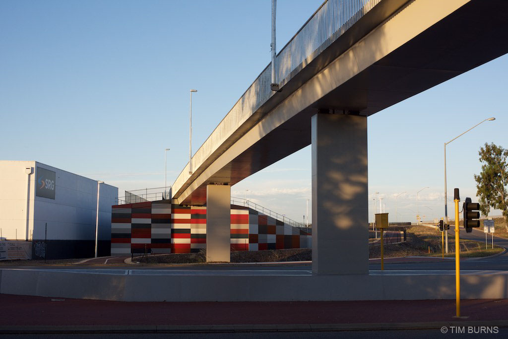
It's impressive. The width of the main path through this area has been made to the new PSP standard of 4.0 metres. On the bridge section, the width is actually 4.6 metres between the railings. This bridge eliminates the need to make a multiple stage crossing of the busy intersection at ground level.


The span across Orrong Road is about 120 metres long, plus there has been significant earth works on both sides to achieve a gradient suitable for cycling. 


There are three additional side-ramps connecting to the main path. The overall length of the project must be around 300 metres.


For comparison, the photograph below shows the much-lauded Cycle Snake / Cykelslangen bridge in Copenhagen. It's 4.0 metres wide between top rails and 4.6 metres at ground level - very similar. And its length, is 190 metres. Overall, the Perth bridge was a bigger project.

Cykelslangen, Copenhagen

Orrong Road and Roe Highway are part of a road network designed for very large trucks with oversize loads. The heavy industrial area of Welshpool is often the starting point for massive loads travelling to mine-sites in the state's north-west and eastern goldfields. The height of this cycle bridge has been designed to accommodate trucks with oversize loads up to 6.5 metres high traveling underneath. A standard truck has a maximum height of 4.3 metres.


This extra height requirement would have resulted in the whole project becoming larger and more costly. It would have required many more tonnes of earth works and much larger retaining walls. The hills here are not natural. This was originally a flat, swampy area. 


The path is not busy. You can visit here for more than an hour without seeing anyone on foot or on a bike. Why was it built? I'm not complaining, but it's an obvious question, without an obvious answer.  I suppose this would be called building-for-the-future. This is amazingly good infrastructure in an area with a mode share that is probably less than 1%. The Western Australian state government has made a commitment to expand the PSP network within a 15 kilometre radius of Perth. This is part of that process.


The Orrong Road bridge has been done without fanfare. I have not been aware of any media release or special announcement. It's part of the large Roe Highway Upgrade project which has a budget of $41 million. This connects with the even larger $1 billion Gateway WA project. Perhaps when there is so much money flowing for highway construction, building a top-class cycling bridge at same time is made easier.


I've called it a cycling bridge but officially these are shared paths. Curiously, Main Roads WA list this as a "footbridge" even though pedestrians are highly unlikely to use it. The residential area of East Cannington nearby rates as a "car dependant neighbourhood" on Walkscore. Many of the streets don't have footpaths and it is common to see three or more cars parked in the front yards of houses.


Perth is not a cycling utopia. We have some good parts but there are still lots of missing links to the PSP network. There are also missing bridges. The_Causeway across the river between Victoria Park and East Perth is an example. It's much closer to the central city than the Orrong Road bridge and has potential to be one of the main cycle routes into the city for commuters. Currently, pedestrians and people cycling share a bumpy, narrow bi-directional path on the southern side of the two bridges. The two-metre wide path is used by a lot of pedestrians and this will only increase when the nearby high-density Riverside development is complete. There has been talk about parallel cycling bridges for several years.

The Causeway shared path
The Causeway

Update 20 December 2017
The Department of Transport have provided some information on the Orrong Road bridge:

"The rationale behind the bridge was that this location would have been the only at grade crossing on the Roe Highway PSP between Kwinana Freeway and Tonkin Highway.  The new bridge and construction of the missing 1km of PSP have resolved this issue and the route now provides a great safe link into the hills for the more serious rider and recreational opportunities for local residents.  It also ties in nicely with the extensive Gateway project PSP network and the under construction Northlink project.  Ultimately, it all forms part of the high level PSP network that will cater for commuters, recreational cyclists and training cyclists."


Tuesday 5 September 2017

We paint streets and ignore parking

Reading Mark Wagenbuur’s recent blog post about creating a contra-flow cycle facility in the Dutch city of ‘s-Hertogenbosch reminded me of a stupid Australian version in Adelaide.

During the Velo-city conference in 2014 we visited a couple of primary schools to learn about the Way2Go education program in South Australia. At Sturt Street Community School we were shown   how the school’s main outdoor sports area was located a few blocks away. The local government (City of Adelaide) was in the process of improving access to the sports ground and proudly showed their proposal to allow contra-flow cycling on Little Sturt Street.


Travel south from the school to reach the play area.

Little Sturt Street had one-way motor vehicle traffic in a northerly direction. There were parking bays on both sides of the street and a central travel lane. I was astonished to learn City of Adelaide's “improvement” for the children was to encourage contra-flow cycling in the existing travel lane, but planned to keep both rows of car parking. The law was changed to allow cycling in both directions, yet no additional space was allocated.


Little Sturt Street, Adelaide

The City's strategy involved painting a short entry lane to feed cycle traffic into the path of oncoming cars at the northern end; and to provide another short section of painted lane at the southern end for anyone who survived. These treatments have now been completed and can be seen on the current Google Street View images below.

Painted lane at northern end 


Southern end

Another element attempting to encourage cycling was the addition of a painted design on the street surface at the intersection with Maxwell Street. This place-making exercise involved the neighbourhood children with intention to slow traffic and give the children a feeling of ownership.

Maxwell Street intersection 2014

City of Adelaide has taken a lot of care to consider the minor and decorative details of the street. But, they have not solved the obvious problem: there are too many parked vehicles occupying valuable space that should be used to provide a safe cycle track.

The s'Hertogenbosch street described on the Bicycle Dutch website had one row of car parking and one travel lane. All of the car parking was removed to ensure enough room for safe cycling. The Adelaide street is wider, only half of the car parking would need to be removed to achieve a similar result. Is that possible?

The City of Adelaide currently has 44,700 publicly available car parking spaces. This is the most parking of any Australian city, more than Sydney and Perth combined. Adelaide's total includes 18,400 on-street parking spaces in an area of just 15.5 square kilometres. 

It is interesting to compare the two Dutch and Australian streets. Both are inner city streets with a mix of residential and commercial use. They are a similar length: 150 - 250 metres. Both had a need for contra-flow cycling. The potential cycling traffic in the Dutch street would be a mixture of people of all ages. In the Australian street there could be people of all ages, but it was specifically targeted at the needs of primary school children.

In both cities car parking is considered a valuable commodity, however car parking is probably more valuable in the Dutch city. As Mark Wagenbuur describes, the s'Hertogenbosch municipality have a waiting list for people wanting car parking spaces, with 200 listed as of late 2015. When the residents finally manage to get a permit they pay €208 per year for the privilege. 

So how did the Dutch city manage to remove eight highly prized on-street parking bays from their city street, yet Adelaide could not? 

Surely Australians care for their children as much Dutch people care for theirs? Have we become so obsessed with our car parking spaces we've become disconnected from logical reasoning?

It has become standard practise in Australia to fiddle around with paint on streets. We upgrade paving, plant trees and create websites to encourage behaviour change yet do very little to remove cars. We are dancing around and ignoring the elephant in the room.

How many local and state government bike plans or cycling strategies include parking management?
Queensland recently released a cycling strategy: the state's vision for the next ten years. The action plan called for leadership from six different state government departments yet I could not find anything about reducing car parking.

On-street car parking is a major restriction for building safe cycling infrastructure. While there continues to be an abundance of car parking in Australia, we will continue to drive. Any long term cycling plan should include a strategy to reduce this problem.

Back in 2014, we watched the children from Sturt Street Community School being taught cycling skills in the small playground at the side of the school.


When leaving I noticed this sign on the street-side gate. I took a quick photograph because I thought it was slightly strange.


The puzzle has been solved with the help of Google Street View. On a normal school day, when Bike Ed is not happening, it seems the staff squeeze their cars onto the school grounds and take over what could be a playground for children. This is an inner-city school with limited space for outdoor play.

Elephants in the room

Saturday 15 April 2017

Albany Cycling City - or not?

The City of Albany on Western Australia's south coast has an ambition to become a "cycling city". Albany is a port and has a population of around 34,000 people and is the oldest permanently settled city in Western Australia, predating Perth by a couple of years. It is potentially Western Australia's most attractive small city. The older, central area has many charming historic buildings with views across a natural harbour.


The coastline nearby is dramatic and there are a number of sparkling beaches with fine white sand.


As with most of Western Australian regional centres, car driving is the major mode of transport. Albany has local buses but the service is infrequent with short duration. The last bus leaves the city centre at 4:35pm on weekdays; 1:40pm on Saturdays, and there are no buses on Sundays or public holidays. If you work nine-to-five in the city and live in the suburbs, you would need to drive a car, ride a bike or walk. Albany's low density would make life difficult for anyone just relying on walking. Using a bicycle is a logical option if the riding environment is good.


In 2014 the Cycle City Albany Strategy 2014-2019 was published (summary here 2.8 MB PDF or the longer version here 30.5 MB PDF). It is admirable effort for a city of Albany's size. In conjunction with Cardno consultants, the state government, local businesses and the community the have produced 389 pages of detailed study and proposals.


The five key objectives are:
1. The Cycling Network - To develop and maintain a bicycling network of safe, connected and accessible routes and facilities. 
2. Cycling participation - To be a city where walking and cycling becomes the easy choice for travel of trips of up to 5 kms around identified community hubs.
3. Safety and respect for all users - To develop a bike riding culture in the City of Albany so that cycling is seen as a legitimate and normal use of the road, with mutual respect between all users. 
4. Cycling Tourism - To be a city that is recognised as a prominent regional cycling destination, delivering economic and tourism benefits for the community. 
5. Management and implementation - To develop management mechanisms to support and guide the ongoing implementation of the Cycle City Albany Strategy (2014-2019).

These objectives seem reasonable. They are the sort of goals you would expect for any city wanting to improve, but what is the desired result? For example, Albany's mode-share for bike trips at the start of the strategy was around 1%, what percentage gain is Albany trying to achieve?

The use of the term "Cycle City" is bold. For anyone who has travelled in Europe it brings to mind wonderful cities where bike riding is normal and done by a wide range of people. Many of those cities have a bike mode-share of 20% or higher.


There are a lot of factors involved in having a good cycling city. Mode-share is important, so is the quality of infrastructure, but also, social acceptance and driver behaviour play a big part.

The City of Albany is promising a lot. The Mayor, Dennis Wellington said:
"we want to transform Albany into one of Australia's best cycling destinations, including both on and off road cycling. We aim to do this by improving cycling infrastructure, encouraging cycling as a legitimate mode of transport, improving the culture surrounding cycling, and by encouraging more cycle tourism."
Using the term Cycle City will create high expectations. Albany has had some success with promoting the sport of cycling in the past few years; the Southern MTB festival is a good example. They have also included strategies to improve how bicycle transport is perceived by people. However, the City of Albany's infrastructure proposals which could encourage riding a bike for transport are mediocre and unlikely to deliver any significant increase in riding. The City of Albany is simply setting-the-bar too low.

ON-ROAD LANES

The strategy lists 82 possible improvements (Appendix F - Indicative Works and Funding, page 221). Of these, more than 50 are improvements to on-road infrastructure. I am sure these will be appreciated by the small percentage of Albany people riding a bike now. It may also encourage a few more brave people to dust off their bikes but it will not change the behaviour of the majority of people.

The extension to shoulders of Golf Links Road is an example. This extra bit of space on the edge of the 70 km/h road will be good for the confident sporting cyclists doing training on a Saturday morning but it is unlikely to be used by children travelling to school or by tourists to visit the beach. 


This sort of provision for cycling is nothing special. A 1.5 metre lane on the side of a 70 km/h road is the current minimum standard specified by Austroads. To become a Cycle City, Albany will have to do more, and do it better.

Another disappointing example is Frenchman Bay Road. As the City Cycle Albany Strategy concedes, "this road is the only access to some of Albany's best known tourist attractions...a growing number of tourists were attempting to cycle [to the attractions] and complained about the intimidating  cycling conditions". The road has a speed limit of 80 km/h and no sealed shoulders. In the short term, the City of Albany's fix for this problem has been some share-the-road signs.


Their long-term plan, is to consider the possibility of the widening the road and adding 1.5 metres shoulders. That is simply not good enough for most people. The majority do not feel safe riding a bike using on-road cycle lanes next to high-speed vehicles.  If the City of Albany is genuine about being a Cycle City for tourists there should be a separated cycle track or shared path along the Frenchman Bay Road route.

The Western Australia State Government recently invested $6.1 million to improve two key tourist attractions that are reached via this road: The Gap and the Natural Bridge. The attractions currently have 210,000 visitors per year. How many more visitors would there be if people didn't need a car to get there?


Curiously, the new parking area at The Gap has ten bike racks. They must be expecting pelotons of sporting cyclists or a lot of very brave tourists. The destination has been improved, but not how to get there. These tourist attractions are 18 kms from the centre of Albany and just 7 kms from the suburb of Little Grove. That is a bike-able distance for many tourists. The state government could complete the job and provide funding for a cycle track.


A separated cycle track next to Frenchman Bay Road would provide safe access to other natural attractions within the Torndirrup National Park and also the stunning Goode Beach and village nearby.


SHARED PATHS

The Cycle City Albany Strategy 2014-2019 also includes several shared paths and some of these will be important links for people on bikes. But again, the City of Albany has set low standards. Almost all of the shared paths have been specified as bi-directional with a width of 2.5 metres. Austroads specify this as the minimum width for shared local-access paths and not suitable for commuting by bicycle. 

The City of Albany, in their Strategy, has relegated commuter cyclists to the road. It states that commuter cyclists have "medium to advanced confidence levels...[and] travel speeds are generally higher than what casual cyclists achieve which makes them more suited to riding on the roadway".

This could explain their low-standard approach to paths. Unfortunately they are designing a network for the type of people who are riding now, not the type of people who would be riding if the paths are done to a higher standard.

People commuting by bike only ride on the road if there is not a good alternative. If there is a protected cycle track, or a even a shared-path of good standard and reasonably continuous priority along the same route as the road, they will not ride on the road with motor traffic. The paths should be smooth and not stop at every driveway and side street.  An example below.


Albany should design for the majority of people who would like to ride a bike, not just the 1% who are riding now. It could then become a cycling-city with normal commuters like this.


Saturday 1 April 2017

Interview with Mark Wagenbuur

Mark Wagenbuur visits Perth Australia.


Make cycling normal again says visiting bike ambassador


The prolific blogger behind the Bicycle Dutch website said if Australia made it safe, useful and normal for people to ride bicycles they would, especially for short distances.

“Humans are not naturally inactive, they’re made inactive by their circumstances. If active travel is a viable option you immediately take your natural habit again and you move,” said blogger, filmmaker and newly minted Dutch Cycling Embassy ambassador Mark Wagenbuur.

Wagenbuur, whose short films about cycling in the Netherlands and elsewhere have been viewed millions of times, visited Australia recently to meet with transport planners and officials in Brisbane, Canberra and Perth.

He said Australian cycling planning should focus on bikes for short distance trips to local destinations such as schools and train stations.

Wagenbuur, whose own 50km daily commute starts with a leisurely 2km bike ride to the train station, said creating a network of slow speed local streets around schools and rail stations would support more short cycling trips. It would also shift the perception of cycling from a sports activity to a means of transport for ordinary people.

Changing perceptions

“It’s the same all over in Australia. Everybody seems to wear Lycra,” he said.

“Riding a bike is not seen as a normal activity. It’s seen as a sport. And you have to dress up for it. The whole perception needs to change.

“I was in Brisbane for three days and I only saw one child on a bike and that’s really telling you something. That’s a shame, it tells you it’s not safe for everyone.”  (For more impressions of Brisbane by bike, see Bicycle Dutch’s 2013 film. He also did one on Sydney.)

Common Australian cycling initiatives such as painted lanes, encouragement campaigns and maps don’t get people on bikes with Wagenbuur saying the key is in creating narrow, slow speed suburban streets of 30km/h where bikes and cars can comfortably share the road. On higher speed roads dedicated infrastructure that separates bicycles from car traffic is necessary.

“A lot of people still think Dutch cycling means cycle paths everywhere and that’s just not true. You don’t have to have separated cycling infrastructure everywhere; just on some key roads,” he said.

‘Cultural’ Dutch biking a myth

Wagenbuur also rejected the notion that the Dutch ride bikes for cultural reasons.

“It’s a myth that the Dutch cycle because it’s somehow cultural or we’ve always done it. No, the Dutch cycle because it’s easy, cheap and convenient.”

“After world war two we embraced the car, the car was the future. There were big plans for highways right through Amsterdam but when they started tearing down buildings, then people started to ask what’s going on?  The whole idea of what a city was started to shift.”

With a new mindset about cities and a skyrocketing road toll, which included many child deaths, it wasn’t until the 1970s that the Netherlands shifted away from car-oriented transport planning, he said. The new “people-friendly” approach focused on narrower, slower and safer streets and made bike riding possible for people of all ages and abilities.

(This history is explored in Wagenbuur’s short film How the Dutch got their cycle paths).